Monday, April 11, 2022

3 days in Yosemite


My friend Steve and I planned a three day weekend in Yosemite.  His Friday meetings ended early so we left sooner than expected and could start hiking Friday instead of camping in the valley the first night.  Thanks for driving Steve!


Mark and Steve

View from the car on drive in

View from the car on drive in

We grabbed some snacks at the mini grocery store in the valley on our way to fill out the self serve permit. 

Filling out the permit

Starting from Backpackers Parking Lot

We started hiking at 3pm.  The weather was perfect, we both wore shorts and traffic on the trail was light (for being so close to the valley).  By 5pm we made it past both waterfalls and were on the flat trail to Little Yosemite Valley and the backpackers campground.  

Beautiful Scenery (Waterfall bypass)

We arrived at the campground and found a spot, pitched the tents and filtered water.  Steve filled up his dirty water bag when we left the river and kept it overnight in case he needed water in the morning (very clever). 

By 7pm the tents were up

Lots of Backpackers so the park has toilets at the campground

The Bear Box (for food storage) made a perfect table

Dinner

For dinner Friday I had couscous with veggies (a very good base), but then I tried to be fancy with the ingredients.  First I added bone broth to the couscous, which normally is not a problem by itself, but then I added a spicy tuna packet.  I should have added either the bone broth or the tuna, but not both.  The taste was a bit overpowering.  I paired it with Hammer Recoverite.  Steve had noodles with tuna and almond butter.  Fewer ingredients is the trick.  

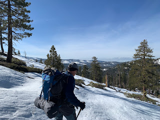
I was very warm when I went to bed, but about 1am had to put on my beanie and puffy jacket because I started to get cold.  Saturday morning we woke around 6am and started our day.  The tent bottom was a little wet, but I flipped the tent over for a few minutes and it mostly dried.  I made my shake the night before, so I was ready to start hiking in a few minutes.  The sun was not up yet so we hiked with jackets, hats, and gloves.  We finally saw the sun around 7:30 (we were in a valley so the mountains blocked the sun).  By 10am we reached Clouds Rest.

View from Clouds Rest Summit

I was a bit faster than Steve so had time to lay out my tent to finish drying and enjoy the views.  The ridge has some sections with near vertical cliffs on either side, so Steve took the bypass around the ridge and I walked the ridge. 

Walking Along the Ridge

Due to the snow and lack of tracks we had a delay finding each other.  Once reunited we checked the map and I used our GPS location on Strava to make sure we followed the trail.  Since Strave only loads the map section you are in, and only when connected to data, I only had about a mile of trail till we dropped off the loaded map.  I didn't have data so we needed to use Steve's phone at that point because he had an app that let you download maps to use offline.  It was a good thing we used the app because one part of the trail was tricky and we would have had a hard time without the extra help.

Steve at Lunch

Mark's Pizza wrap with Guacamole

Hanging water bag connected to gravity filter, filling drinking bladder

It did not take long to drop below snow level.  We filled up on water and looked for a spot to camp.  

Saturday Night


Mashed potatoes, sausage, veggies, red pepper flakes

Spectacular Sunset

We were in our tents a little after 8 (I think it was closer to 7:30).  That night I froze.  It was so cold I had chucks of ice in my water bladder and water bottle in the morning.  I went to bed wearing all my jackets and even rain pants.  At about 1am my legs were so cold I took off a jacket and wrapped it around my legs, lucky I brought the fleece because it was needed.  It was an odd feeling because at some points during the night I was warm, but because I didn't trust the new sleeping bag I was never relaxed.  As the sun started to come up I strained to hear Steve making sounds so we could get up.  Once I heard some movement (his sleeping quilt makes a noise when he moves from rubbing on his ground pad) I yelled and we agreed to get up.  My hands and feet were frozen and I tried to warm up with lunges.  I don't have any morning pictures till around 8 when we stopped to get water.  By this time my hands and feet were feeling normal again.  

This mess of logs has a creek under it, we filled our water here

With our water bottles/bladders full we started the decent back to the car.  It was Sunday and the traffic heading to Clouds Rest and Half Dome (cables were still down) was about 15 people.  But when we reached the waterfalls the number of people greatly increased.

Saturday we saw one person, Sunday we saw this

Most people don't venture past the waterfalls, so traffic increased the more we descended.  This time we decided to take the Mist trail, and it was misting!  My right side was facing the river and it was wet by the time we cleared the section.  

This section is the narrowest

We were back at the car by noon and driving home by one.  We stopped at the mini grocery store so Steve could get a snack, I had a Recoverite.  

Per Strava:
Friday
    6.34 miles, 2,800 feet of elevation gain, 2:30 moving time
Saturday
    12.2 miles, 4285 feet of elevation gain, 5:20 moving time
Sunday
    10.1 miles, 147 feet of elevation gain, 4:00 moving time

Notes:
  • I need to rethink the sleeping bag I use.  I will probably look into a lighter 15/20 degree bag to replace the Kelty.
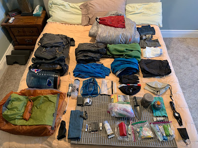
  • Fewer ingredients 
  • Saturday we had lots of snow and route finding, so 12 miles felt like a long day
  • Friday and Sunday were below the snow line so we made good time (2.6 miles per hour)


Thursday, April 7, 2022

Yosemite Gear Review for April 8-10

After my last trip to Yosemite I wanted to change a few things with my gear.  First I decided to use my REI discount (on one regular priced item) to buy a new sleeping bag.  I decided on the REI Magma 30, because it has the best weight to warmth ratio.  The stated weight for long was 1 lb 6oz.  My current favorite sleeping bag (the one I used last time, the Kelty Cosmic 20 long) is 2 lb 16 oz.  I was excited to save the weight and also the Magma packs smaller.

My fleece takes up a lot of space so this time I brought a light running jacket to see if I could ditch the fleece on future trips.  I still took the fleece, but was not going to use it unless really needed.  I also took a lighter long sleeve sleeping shirt.  

Planning for a longer hike this summer, I also packed my Charmcast charger (6.6 oz) and power cord to charge it, and power cord to charge my phone.  I would like to find a solution that has one cord to charge the phone and charger.

Without water or food I was at 18 pounds (last trip I was at 19.6 pounds)


Monday, March 28, 2022

Yosemite Weekend Review

Woke up early Friday morning, well before my alarm.  Since I was up I grabbed my food and gear and left the house.  It was so early I made great time, cruise control most of the way and ended up in Yosemite Valley at 8am.  The Wilderness Center was closed so I went over to the Visitor Center, and it was closed too (opens at 9am).  As I looked around I saw a self registration station!  Once I filled out my permit I was on my way.

Yosemite Fall from the Valley; 8am

After parking and arranging my gear I was hiking by 9am.  I passed about 15 people on the way up, mostly in groups of 2 or 3, so the trail was not busy.  It was easy walking so my training is paying off.  Once near the upper falls I was getting misted on, and water like rain was coming off the trees.  It was nice to be cooled off since this section has sun and can be warm when working hard.  At the top I took a left at the trail junction, heading up Yosemite Creek.  The path was quickly covered in snow.

Snow Covered Trail

At the junction for El Capitan and Eagle Peak I could not find the trail.  I used my map and compass to figure out the direction and made my own path.  The snow was holding up but occasionally I would sink in, then I had a small section I was going in ankle, then knee, then hip deep.  I had to be very careful around down trees because the snow will melt around them causing voids that you can easily fall into.  I was on the south side of the creek and the trail was on the north side, so I followed the creek up, it was impossible to cross so I kept climbing.  I found this great rock clear of snow for lunch, and an easy spot to cross.

Lunch Spot at Creek Crossing

I needed water and was excited to try my new Platypus GravityWorks filter.  I connected it directly to my Camelback reservoir (using a quick disconnect from Camelback) and lifted the bag ready for gravity to do the work.  I checked to make sure the Camelback valve was open because the flow was so slow.  Nothing worked, the flow rate was horrible.  I had to squeeze the bag to get water out.  Finally topped off I crossed the creek and found the trail on the other side.  Following it up the hill to the meadow I had snow free spots, and the meadow only had one section that was difficult to cross without getting wet.  

Water Crossing at Eagle Peak Meadows

This photo makes it look easy, but after the log you climb onto the snow mound, no idea what is under it.  Then you hop some water to the other snow mound and work your way around the dead tree without the limbs knocking you in the water to jump another few feet to the next snow mound.  After that it was easy to follow the trail.  I headed up Eagle Peak trail to find dirt and camp the night.  Along the ridge I found lots of snow free flat spots.  

Friday Night Camp

Total for the day was 7.5 miles and 3,800 feet of elevation gain in 3:30.  I had time to spare as the sun was not setting for several hours so I just reflected on being alone.  I am not used to hiking alone so it was very emotional.  

Saturday I woke up early, before my alarm, and was on the trail quickly since I don't need to cook for breakfast.  My water didn't freeze, but was getting low.  If my filter didn't work better I was going to go home, but the snow was firm and I was making good time so I picked up the pace and was back at my lunch spot from the previous day in 15 min-ish.  I decided to follow the trail others had made and not my original route.  It was easy to follow and with firm snow I was making good time.  Then I lost the trail in a maze of mini creeks and mounds of snow.  I heard voices and saw four guys looking at a large water crossing.  "Is that the trail?" I asked.  They pointed to a log several feet away and said that was the only way they found to cross.  So I made my way to the log, hopping over a few creeks and then climbing onto the log and not even pausing crossed.  I said thanks and someone said "you made it look easy".  I never saw them again as I was now back at the junction and saw my mistake from the day before.  What I thought was just running water was actually the trail.  The snow was still firm so I took off down the trail, I felt like I was flying.  I quickly stopped at the top of Yosemite Falls and the wind nearly blew me over.  

Bridge over Yosemite Creek, Falls on the Right

I filled the "Dirty" reservoir and hooked it up to my Camelback, but zero water was flowing.  I squeezed the bag and freezing water spilled out all over my hands.  Then I noticed the valve on the Camelback was closed.  I opened it up and water began to flow, really fast.  I was so happy.  I think the trick was to get the bag higher off the ground.  Once water was full I headed to North Dome.  The trial was so easy to follow since many others had done this hike.  A few easy creek crossings and I was on North Dome.

Typical Creek Crossing

I made a clothes line and hung my tent to dry the bottom.  While it dried I had lunch.  

Lunch

I met two hikers who came from Snowcreek, and they said the trail was a challenge but they made it and I could follow the footprints they left.  In some cases all I could find was the faint trial they left.  Also, I left my water bottle next to a cool looking rock that I photographed and had to double back to get it.  I made good time to the junction with the Indian Rock trail.  As I followed the trail I thought the people had no idea what they were doing (but they did, I checked my GPS later and the trail I followed was exactly on the trail).  They were going straight down the hill, but since I knew the topography I knew the trail came out at the highest point in the valley to my left.  I found the trail signs just above the snow at the 4 way junction with Lehamite Creek.   I could not find my trial when I saw a guy coming my way (and looking lost).  I yelled and he came my way.  He told me the general direction of the trail and that this section was hard to follow but the rest was not so bad.  After we parted I headed down Lehamite Creek to get water, then came back to the junction to find a clear spot for camp.  I headed up the hill since the ridge would be snow free.  

Amazing Sunset at Saturday Camp

Total for the day was 13.4 miles and 3,100 feet of elevation gain in 5:41.  

It was a very windy night, but I slept well and again woke up before my alarm.  I knew the trail was going to be a challenge so I wanted to start early while the snow was firm.  I am glad the guy pointed me in the correct direction because the snow was firm and didn't leave much trail.  After about 10 min of really focused trail finding the path became clear and I made good time.  

Waterfall

After leaving the waterfall the trail headed south and the snow changed to much firmer, even frozen in places and I fell hard on my right side.  I slowed my pace and was glad, many frozen sections.  

Trial Conditions

By the time I reached Snow Creek Bridge the trial was clear of snow.

Snow Creek Bridge

Another opportunity to fill up on water and the Platypus system worked great.  The rest of the trail was snow free and downhill to the valley, only 1.7 miles away.  I made good time on the way down but my legs and knees were starting to feel it.  It was Sunday and I passed about 5 people on the trail.  Once in the valley I saw a lot more people.  I decided to skip the bus and hike back to the car and hiking on flat surfaces felt weird.  Once back at the car I drove to a pull out near the water to clean up, have a Strawberry Recoverite and snack before the drive home.  

Bananas, Raisins, and Peanut Butter

Total for the day was 11.5 miles and 400 feet of elevation gain in 4:00.  Elevation loss was about 4,000 feet.    

Wednesday, March 23, 2022

Yosemite Weekend Food Plan


Leaving Friday for Yosemite, and returning home on Sunday.  Here is my food plan.


Friday 

  • Shake/multivitamins at home before I leave
  • Eat breakfast on the way
  • For the trail
    • Hammer Nutrition HEED and Perpetuem
    • Two Hammer Bars
    • Peanuts to snack on
      • No lunch since I will be stating late
  • Mashed potatoes with Silva Jalapeno pepper jack sausage, red pepper flakes, and dried mushrooms
  • Hammer Recoverite and multivitamins
Saturday
  • Same morning routine (Shake/HEED/Perpetuem/Bars)
  • Lunch is pepperoni, sausage, red pepper, crushed red pepper flakes, and guac on a wrap
  • Probar for the afternoon
  • Oatmeal for dinner
  • Hammer Recoverite and multivitamins
Sunday

  • Same morning routine (Shake/HEED/Perpetuem/Bars)
  • Lunch is a wrap with peanut butter, raisins, and dried bananas
  • Probar if needed, since it is a 10 miles hike out I think the extra snack will be good
  • Hammer Recoverite for when I get to the car


Monday, March 21, 2022

Suunto MC-2

While in Yosemite my old Silva compass developed a bubble, so the hands would not freely turn.  This was not an issue because I had Strava recording and it could show my GPS location relative to the road.  We easily found our way, but I needed to replace the compass since I like to go off trail.  The compass I chose was the Suunto MC-2.  It is a bit larger than my old one, but still fits in my hip belt pocket, the dial is much nicer and I like the larger mirror (great if you get something in your eye, or just need to see how bad your hair looks).  


Monday, March 14, 2022

Badger Pass Post-Backpack Gear Review

 What worked:

  • Food was perfect, ended the hike with zero extra food
    • Dried mushrooms were excellent
    • Couscous was delicious
    • Morning shake was fully dissolved
  • Three water bottles worked well
  • Sleeping clothes were perfect
  • Patagonia insulated canister was perfect for cooking dinner/oatmeal
  • Hiking base layer and sun shirt was comfortable and no sunburn
  • Clear bag for general small items (vs. mesh bag) worked well
  • Rain jacket/puffy combo worked well
  • Pack with food/water weighed 42.2 pounds at the start
    • Jim's pack weighed 50.2

What can be improved:

  • Ran out of fuel, the small canister did not last
    • next time bring large canister as backup
  • Hotspots on both feet
    • Winter boots are to big, used two socks for better fit
    • Moleskin kept blisters from getting worse
    • Next time consider normal hiking shoes since very little time was spent in snowshoes
  • Two pair of gloves was redundant
    • Next time bring one pair of mid-weight gloves
  • Beanie was not as warm and didn't cover ears with sunglasses on
    • Next time bring hat that covers ears with sunglasses
  • Compass had an air bubble in it and didn't get accurate reading


Sunday, March 13, 2022

Badger Pass; Day Three

 The clocks moved forward an hour last night, and clouds had moved in.  

Sunrise

We were up by 7:30 and as I tried to heat up water for oatmeal the fuel canister died.  We both had enough water for the hike out, but I missed the warm breakfast.  By 8:30 we were hiking.

It felt steeper climbing it

I was wearing both socks again, and also put on new moleskin (I used all the moleskin I took on the hike).  We followed the ridge as far as we could before turning towards the road.  The views were outstanding.  

Mark and Jim

It was a challenge to walk across a slope because of the blister on my left foot, and my right ankle was feeling sore, so we decided to just walk straight down from the ridge. This was easy since we had snowshoes.  This time I kept looking at Strava to see our exact position relative to the road.  

It was steeper in real life!

By 10:00 we found the road and took the snowshoes off for the hike to the car.  The clouds cleared and we had good weather, but the last portion of the hike was uphill.  Along the way a Ranger asked for our permit and informed us the lower gate would be locked next Sunday and the lifts at Badger Pass would stop running.  He said the park may be closing Badger Pass early to plow the road in an effort to speed up the construction.  We were happy to see the trails for Dewey Point because that indicated the rest was downhill.  We arrived at the car by 1:00, Jim was very pleased because he predicted we would finish by 1:00.  

Strava had us at 9.2 miles and 840 feet of elevation gain.